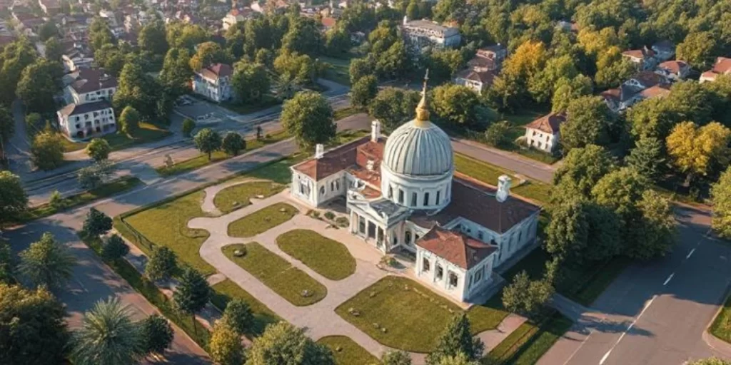
Staying ahead in the quick-moving real estate and architectural sectors of today calls for interesting visual storytelling as much as it does for a nice design. Aerial 3D Rendering is therefore quite useful. Aerial Rendering provides a bird’s-eye view of whole developments, enabling stakeholders to see not only the buildings but also how they fit within their surroundings, so providing a more complete picture than conventional ground-level photos.
Aerial Rendering Services have become more important in marketing, planning, and communication as rivalry grows. These renderings show how properties interact with the surrounding environment using sophisticated CGI to present a photorealistic view before construction even starts. This not only amazes customers and investors but also lets architects and builders improve their designs early on.
In the end, Aerial 3D Rendering is a strong tool for quick development, lower mistakes, and improved decision-making as much as for looks. This book will look at how it functions and why it is changing the way projects are conceived and constructed.
Comprehending Three-dimensional Aerial Rendering
Aerial Rendering is the process of producing digital visualisations of architectural designs from an elevated viewpoint. Aerial 3D Rendering offers a complete view of a property as its whole, including its surroundings, unlike conventional ground-level renderings. Whether in urban areas or natural settings, this all-encompassing viewpoint is priceless for grasping how a new project fits into its surroundings. It provides realistic infrastructure connectivity, spatial relationships, and scale. From this higher perspective, clients, developers, and architects can also evaluate how the project fits with adjacent buildings, green areas, roads, and public spaces—thereby enabling Aerial Rendering Services to be crucial for informed planning and decisions.
Aerial Rendering’s Evolution
The evolution of Aerial Rendering marks a transformative shift in the way developers, architects, and marketers present their vision. In the past, showcasing a property’s scale and spatial context relied heavily on ground-level photography, flat blueprints, or physical scale models. While these traditional methods had their place, they often lacked the immersive impact and clarity required to fully communicate a project’s scope—especially within its environmental context.
Aerial Rendering Services’ debut completely transformed the situation. These services now generate high-resolution, photorealistic images that show not only the architecture but also its surroundings—roads, parks, skyline, neighbouring buildings, and more—using the power of cutting-edge digital tools and sophisticated rendering engines. Well before the first brick is laid, this all-encompassing perspective lets stakeholders see how a suggested development fits with its surroundings.
Aerial three-dimensional rendering has increased its use throughout the whole project lifetime beyond just enhancing the visual quality. Its use is broad from conceptual planning and design approvals to investor presentations and marketing efforts. Community involvement also depends on it significantly since it provides citizens and civic authorities a clear, easily accessible view of how a future building will affect the current scene.
The future of Aerial Rendering seems even more promising as technology develops with improved rendering software, higher-resolution drone photography, and real-time rendering capabilities. It’s not only a trend; modern architectural and real estate development are increasingly adopting it as standard practice.
Aerial 3D Image Creation Process
Creating Aerial 3D Renderings calls for technical knowledge and artistic vision combined in a careful process. Here is a step-by-step summary:
- First Modelling: Using geometric shapes, artists start by building a simple 3D model of the suggested building.
- Textures, materials, and lighting are added to increase realism.
- Contextual Integration: Surrounding elements including neighbouring buildings, roads, and landscapes are included to give context.
- Last Touches: The visualisation is refined using advanced rendering methods and image-processing tools, therefore guaranteeing its accurate representation of the intended project.
Incorporating real-world data like topography and current infrastructure guarantees that the rendering is not only aesthetically pleasing but also contextually correct. Stakeholders need this degree of detail to be able to make wise choices about project viability, budgetary concerns, and design changes.
Technologies and tools
High-quality Aerial 3D Rendering is produced by a set of specialised software and cutting-edge tools. This approach creates interesting images that serve both functional and marketing goals by means of architectural accuracy combined with photorealistic art.
Starting with industry-standard software like AutoCAD, SketchUp, and 3ds Max, modelling lets architects and artists build thorough, accurate representations of structures and layouts. These tools provide the adaptability to create intricate architectural components and precisely hone them.
Once the 3D models are finished, rendering engines such as V-Ray, Lumion, and Corona Renderer are used to mimic realistic lighting, shadows, textures, and environmental conditions. These rendering tools create high-resolution images that mimic real-world appearances with remarkable accuracy from static models.
The procedure also includes satellite photos and drone photography to seize the real terrain and surroundings. Especially in large-scale urban or natural developments, these act as references to guarantee spatial accuracy and contextual relevance. This integration lets artists put the 3D model into actual environments, therefore improving realism and relatability.
Post-production may involve other tools like Photoshop or After Effects to refine the final output, include notes, or improve presentation quality. These technologies taken together create a smooth process that helps to produce interesting and informative Aerial 3D Renderings, enabling modern architectural visualisation.
Advantages of Aerial 3D Rendering
1. Early Fault Finding
Architects and developers can spot and fix design problems at the beginning by means of the above-project visualisation, therefore conserving time and money. This proactive strategy guarantees a smoother development process and reduces expensive changes during construction.
2. Improved Marketing Appeal
By highlighting the project’s whole extent and integration with its surroundings, Aerial Rendering Services helps to create interesting images for use in marketing efforts, therefore drawing possible buyers and investors. In brochures, websites, and presentations, high-quality renderings are effective tools that leave a lasting impact on viewers.
3. Drawing Investors
In investor presentations, high-quality Aerial 3D Renderings are effective tools that offer a clear and thorough picture of the project, therefore building confidence and enabling funding. Investors can more clearly see the possibilities of the project and how it fits with market needs.
4. Complete Property Presentation
These renderings provide a full picture of the property’s offerings by allowing for the display of features otherwise challenging to capture, such as rooftop amenities, parking layouts, and landscaping. This all-encompassing perspective helps to properly communicate the value offered by the project.
5. Economic Efficiency
Especially when changes are required, Aerial 3D Renderings are more affordable than physical models or repeated 2D plans since alterations can be made digitally without the need for reprinting or remodelling. This adaptability results in notable savings in both time and money.
6. Simple Teamwork and Sharing
Easily shareable across platforms, Digital Aerial Renderings helps architects, developers, and clients work together by making sure everyone shares the vision of the project. Seamless communication helps to simplify decision-making and speed up project deadlines.
Real Estate and Urban Planning Applications
Aerial 3D Rendering helps real estate by:
- Pre-construction Marketing: Presenting properties before they are constructed to create interest and guarantee pre-sales.
- Urban Development: Planning large-scale projects by imagining how new buildings will fit inside current cityscapes.
- Infrastructure Projects: Designing and presenting public spaces, parks, and transportation systems in relation to their surroundings.
Aerial Rendering Services helps urban planners evaluate the effect of new developments on traffic flow, environmental sustainability, and community aesthetics by offering a macro perspective. Creating balanced and functional urban environments depends on this all-encompassing knowledge.
Case Studies
Many projects have met their goals by effectively using Aerial 3D Rendering. Residential development in a city, for example, used these renderings to show how the new structures would fit with the current skyline, therefore generating more investor interest and faster approvals.
Conclusion
Staying ahead in the quick-moving real estate and architectural sectors of today calls for interesting visual storytelling as much as it does for good design. Aerial 3D Rendering is therefore quite useful. Aerial Rendering provides a bird’s-eye view of whole developments, enabling stakeholders to see not only the buildings but also how they fit within their surroundings, so providing a more complete picture than conventional ground-level photos.
Aerial Rendering Services have become more important in marketing, planning, and communication as rivalry grows. These renderings show how properties interact with the surrounding environment using sophisticated CGI to present a photorealistic view before construction even starts. This not only amazes customers and investors but also lets architects and builders improve their designs early on.
In the end, Aerial 3D Rendering is a strong tool for quick development, lower mistakes, and improved decision-making as much as for looks. This guide will look at how it functions and why it is changing the way projects are conceived and created.