
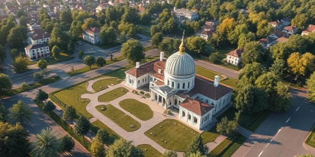
In today’s fast-moving real estate and architecture markets, a good design also needs a compelling visual story. Aerial 3D rendering provides it. By showing an entire development from above, an aerial render reveals not only the buildings but how they fit into their surroundings: roads, green spaces, neighboring buildings and the wider landscape.
For large projects such as master-planned communities, mixed-use complexes, corporate campuses, resorts and infrastructure schemes, no single eye-level view can tell the whole story. A street-level render captures a facade beautifully but hides the project’s scale, site planning and context. This guide explains what aerial rendering is, why large developments need it, the types and camera angles available, how aerial renders are made, and how to make them look truly photorealistic.
What Is Aerial 3D Rendering?
Aerial 3D rendering is a form of exterior visualization that presents a building or development from an elevated viewpoint, simulating the perspective of a drone, helicopter or satellite at different heights. Also called a bird’s-eye view rendering, it places the project in its real geographic context: surrounding roads, neighboring buildings, parks, water and the wider urban or natural landscape.
Unlike a standard exterior render of a single facade or courtyard, an aerial render captures the whole footprint of a project, including its layout, scale, density, landscaping, circulation and environmental integration, in a single image.
How Aerial Rendering Has Evolved
Developers once relied on ground-level photos, flat site plans and physical scale models to show a project’s scope. These lacked the impact and context needed to explain large schemes. Modern aerial rendering combines advanced modeling, photorealistic render engines, drone and satellite imagery and real survey data, so stakeholders can see exactly how a development fits its surroundings before any construction begins. It is now used throughout the project lifecycle, from concept and approvals to investor presentations, marketing and community engagement.
Why Large Developments Need Aerial Renders
Scale Is Impossible to Show from Ground Level
A community of 200 homes, a campus of six connected buildings or a mixed-use scheme combining retail, residential and hospitality cannot be understood from one street-level view. An elevated render shows its true scope and organization at a glance, and aerial animation combined with drone footage takes this further.
Site Planning Needs a Macro View
Large developments involve complex site decisions: pedestrian routes, vehicle access and parking, landscape zones, building orientation for sunlight, stormwater management and phasing. An aerial render makes these elements visible and easy to check during design reviews.
Investors Need Confidence
A photorealistic aerial view of an entire development, with accurate massing, landscaping and context, turns an abstract investment proposal into something credible and tangible, and signals professional rigor.
Planning Boards Need Context
Planning committees, zoning boards and local authorities use aerial views to assess traffic impact, shadows on neighboring properties and green space provision. See what planners and councils expect from exterior renders and infrastructure rendering for urban planning.
What a Good Aerial Render Reveals
- Building massing and proportion: how structures relate in height and footprint to each other and to their neighbors.
- Landscape integration: green spaces, planting, water features and outdoor amenities.
- Circulation and access: how pedestrians, cyclists and vehicles move through the site, including entrances, paths and parking.
- Hard-to-capture features: rooftop amenities, parking layouts, pools and courtyards.
- Phasing: completed and future phases shown together to explain the long-term vision.
- Environmental fit: how the project sits within its terrain, tree canopy and distant landscape.
Benefits of Aerial 3D Rendering
1. Early Problem Detection
Seeing the whole project from above helps architects and developers spot and fix layout or design issues early, avoiding expensive changes during construction.
2. Stronger Marketing and Pre-Sales
Aerial renders show a project’s full extent and setting, making them highly effective in brochures, websites, hoardings and presentations. For residential communities, buyers respond to the neighborhood and its amenities, not just the house, which helps off-plan sales.
3. Investor Appeal
A clear, complete picture of the project builds confidence and helps secure funding and partnerships.
4. Community Identity and Show-Home Context
Aerial views communicate a neighborhood’s character, including its streetscapes, green spaces and community facilities, and show buyers where a show home or plot sits within the finished community. See more benefits of exterior home rendering.
5. Cost Efficiency
Digital renders are cheaper to update than physical models or repeated 2D plans, since changes are made in the model without rebuilding or reprinting.
6. Easy Collaboration and Sharing
Digital aerial renders are simple to share across teams and platforms, keeping architects, developers, consultants and clients aligned and speeding up decisions.
Types of Aerial Renders
Choosing the right type for each project phase and audience makes a big difference. See all variants of 3D exterior rendering.
| Type | What it shows | Best for |
|---|---|---|
| Photorealistic aerial | Fully detailed materials, trees, shadows and atmosphere | Marketing, investor decks, planning submissions |
| Conceptual aerial | Simplified massing and schematic landscaping | Early design reviews and concept approvals |
| Twilight and night aerial | Glowing windows, lit paths, plazas and landscape | Hospitality, mixed-use and premium residential marketing |
| Seasonal aerial | The same scheme in summer, autumn or winter | Resorts and landscape-led developments |
| Phasing renders | Completed and future phases side by side | Multi-stage masterplans, buyers and investors |
| Aerial flythrough animation | A moving camera over and around the site | Launch videos, websites and sales suites |
Choosing the Right Camera Angle
Each aerial angle communicates something different. Camera tilt is measured below the horizon. Learn more in our guide to the best angles for exterior rendering.
| Angle | Camera tilt | Best for |
|---|---|---|
| High-altitude overview | Steep, roughly 60–90° down (near top-down) | Masterplans, planning submissions, investor overviews |
| Medium-altitude perspective | About 30–60° down | The most versatile view for marketing and presentations |
| Low-altitude aerial | About 10–30° down, drone height | Architectural character and individual buildings in context |
| Oblique aerial | Angled toward one corner or zone | Highlighting a key amenity, entrance or signature building |
How Aerial 3D Renders Are Made
- Site data and context: gather drawings, survey and topography data, GIS information, satellite images and, where useful, drone photography of the real site.
- Terrain and massing: model the land form accurately, then build the proposed buildings and site elements.
- Context modeling: add surrounding buildings, roads, infrastructure and landscape so the project sits in its real environment.
- Materials, vegetation and lighting: apply materials, scatter species-appropriate planting and set a sun position that is accurate for the location and time of day.
- Rendering and post-production: render at high resolution, then refine atmosphere, color and annotations in post-production.
Using real-world data ensures the render is not just attractive but contextually correct, which matters when stakeholders use it to judge feasibility, budget and design changes.
Tools Used for Aerial Rendering
| Tool | Role |
|---|---|
| 3ds Max, SketchUp, AutoCAD | Accurate modeling of buildings, layouts and site elements |
| V-Ray and Corona | Photorealistic lighting, atmosphere and materials |
| Forest Pack and RailClone | Scattering thousands of trees, shrubs and repeated site elements |
| GIS and survey data | Topographically accurate terrain models |
| Lumion and Twinmotion | Faster, real-time workflows for conceptual and intermediate views |
| Photoshop and After Effects | Post-production, annotations and animation finishing |
Explore more rendering tools for landscape design and AI tools for architectural rendering.
Tips for Photorealistic Aerial Renders
- Get the terrain right first. Everything else depends on accurate topography; a flat site on a hilly location instantly loses credibility.
- Use atmospheric perspective. Distant objects should look slightly hazier and softer, which creates convincing depth and scale.
- Match vegetation to the location. Use species that fit the climate and season, at a realistic growth stage. Tropical trees in a temperate city, or decade-old trees on opening day, mislead viewers.
- Cast accurate shadows. Shadow direction reveals orientation and time of day, and matters for planning submissions that assess shadow impact.
- Detail the infrastructure. Roads, paths, parking and service areas are highly visible from above, and their accuracy signals quality.
- Control the focal point. Frame the shot so the eye lands on the key amenity, entrance or signature building.
- Light for drama and accuracy. Choose a sun angle that is both beautiful and correct for the site and time of day.
For more, see best practices for realistic outdoor visualizations and 7 tips to improve exterior rendering.
Applications in Real Estate and Urban Planning
- Pre-construction marketing: generating interest and pre-sales before construction starts.
- Urban development: showing how new buildings fit into existing cityscapes and skylines.
- Infrastructure: presenting parks, public spaces and transport links in context.
- Campuses and resorts: explaining large, landscape-heavy sites with many buildings.
Planners also use aerial views to evaluate traffic flow, sustainability and community impact. Read why stunning exterior visuals help secure approvals and buyers.
Case Study: Youth Camp Campus Walkthrough
See aerial visualization at scale in our youth camp campus walkthrough, a 2:42 photorealistic walkthrough of an entire campus set in a wooded landscape.
Frequently Asked Questions
What is aerial 3D rendering?
It is a 3D visualization of a building or development from an elevated viewpoint, like a drone or helicopter shot, showing the whole site in the context of its surroundings.
When do I need an aerial render instead of a street-level render?
Whenever the project is too large or complex to understand from one eye-level view, such as communities, campuses, mixed-use schemes, resorts and infrastructure, or when planners and investors need to see the full site.
What information do you need to create an aerial render?
Site plans, architectural drawings, topography or survey data and the site location. Drone or satellite imagery and landscape plans help improve accuracy.
Can aerial renders be combined with drone footage?
Yes. 3D buildings can be composited into real drone photos or video of the site, or a fully CGI flythrough can be produced.
Which software is used for aerial rendering?
Common tools include 3ds Max, V-Ray, Corona, Forest Pack, RailClone, Lumion and Twinmotion, combined with GIS and survey data for accurate terrain.
Conclusion
For large developments, aerial rendering is not a stylistic extra but a strategic necessity. It presents a project’s layout, landscape and context in a single photorealistic image, helping developers, designers and planning authorities make confident decisions and deliver compelling presentations. Arktek 3D’s 3D exterior rendering services and architectural visualization services include high-quality aerial renders and flythroughs. Request a fixed quote for your project.
2 Responses